
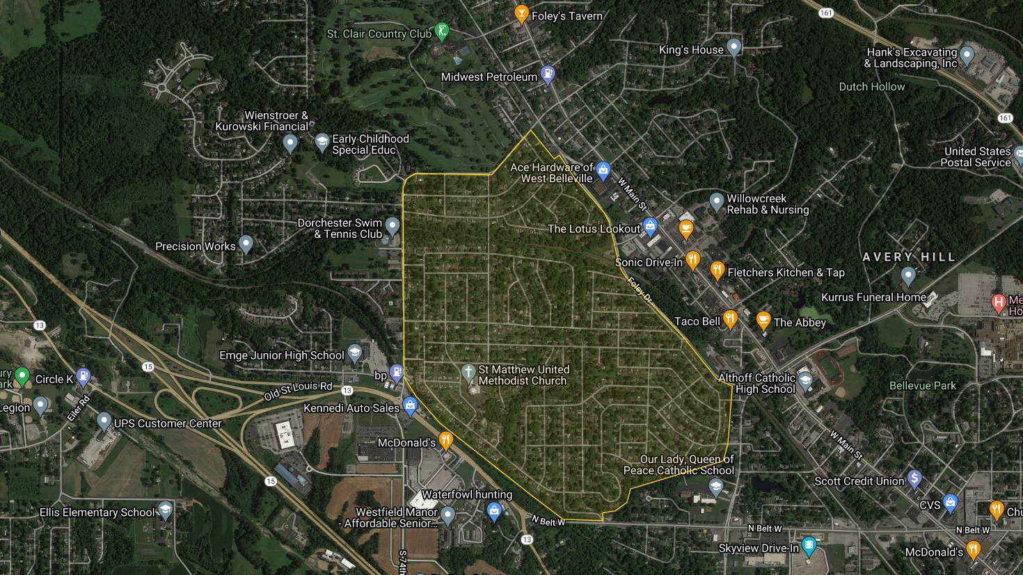
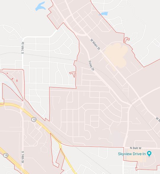
The Ogles Neighborhood is an approximately 441 acre (0.689 mi²) area in Belleville, Illinois bounded by 74th St on the north and west, Foley Dr and Frank Scott Parkway on the east and North Belt West/Illinois Central Railroad tracks on the south. What is commonly called “Ogles”, is actually made up of several different subdivisions, “Atlee Ogle’s Subdivision” is just one of the many subdivisions in The Ogles Neighborhood.
These are the subdivisions in the Ogles Watch Neighborhood Association:
- DAVID OGLE’S (City of Belleville)
- OGLE TRACTS A P (St Clair County/Stookey Township)
- BRIARWOOD ( St Clair County/Stookey Township )
- ATLEE OGLE’S + 1ST thru 12 th ADDITIONS (City of Belleville)
- COUNTRY CLUB ACRES + 1ST thru 5th ADDITIONS ( St Clair County/Stookey Township and City of Belleville)
- COUNTRY CLUB HEIGHTS + 1ST thru 5th ADDITIONS ( St Clair County/Stookey Township )
- MELWOOD (City of Belleville)
- MITCHELL PLACE + 1ST thru 2nd ADDITIONS (City of Belleville)
- MIDWAY TERRACE (City of Belleville)
- RAINTREE (City of Belleville)
- PINECREST +1ST thru 7th ADDITIONS (City of Belleville)
- SHEPHERD HILLS +1ST thru 2nd ADDITIONS ( St Clair County/Stookey Township )
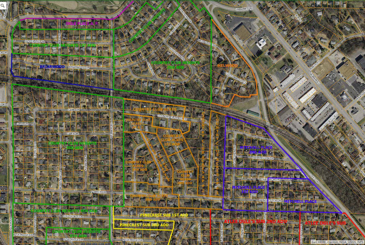
Ogles Neighborhood subdivisions north of Southgate Dr (click image for higher resolution):
- OGLE TRACTS A P
(Stookey Township) - BRIARWOOD
(Stookey Township) - COUNTRY CLUB ACRES + 1st thru 5th Additions
(Stookey Township and City of Belleville) - COUNTRY CLUB HEIGHTS + 1st thru 3rd Additions
(Stookey Township) - MELWOOD
(City of Belleville) - MITCHELL PLACE + 1st thru 2nd Additions
(City of Belleville)
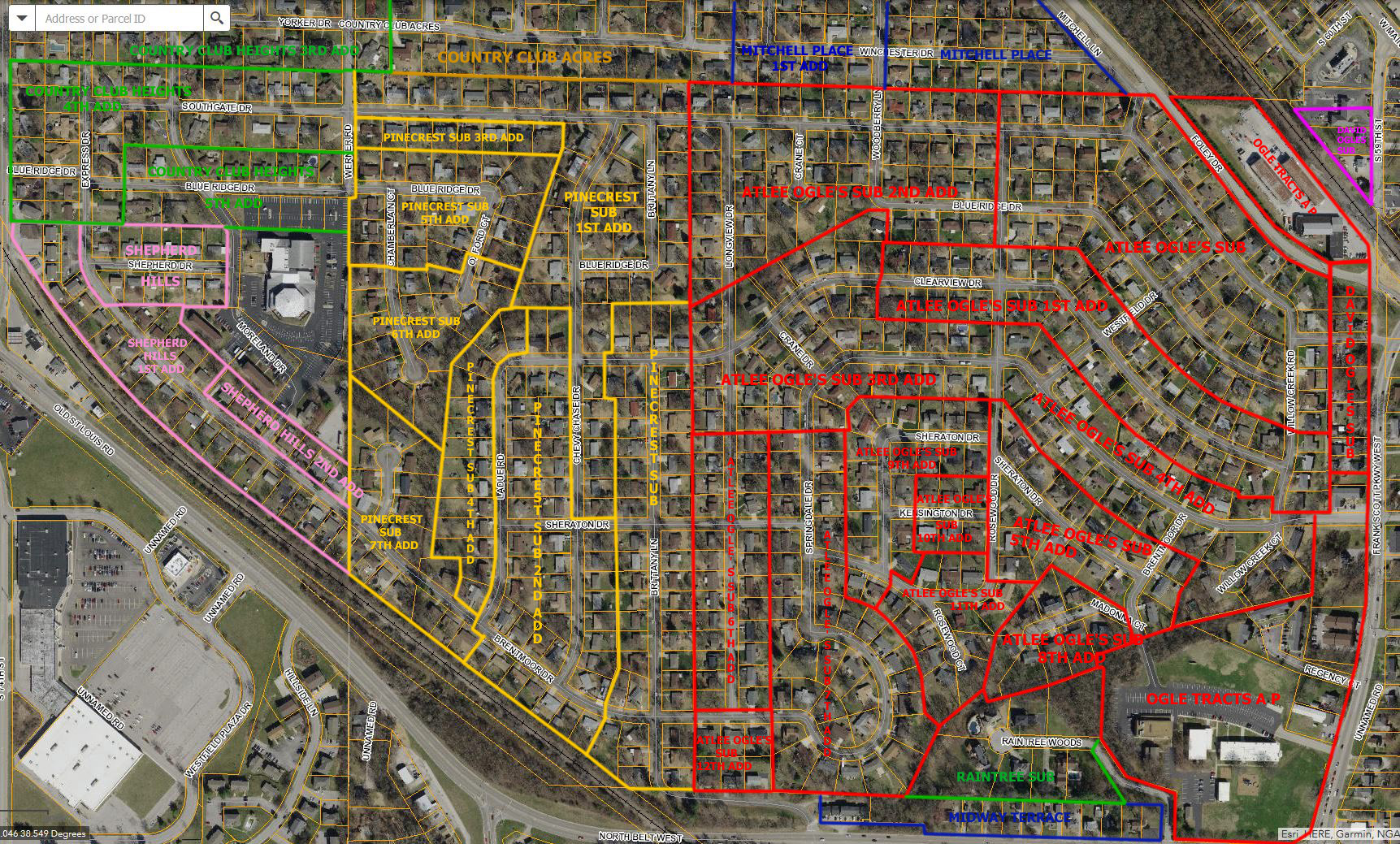
Ogles Neighborhood subdivisions south of Southgate Dr (click image for higher resolution):
- DAVID OGLE’S
(City of Belleville) - ATLEE OGLE’S SUBDIVISION + 1st thru 12 th Additions
(City of Belleville) - COUNTRY CLUB HEIGHTS 4th and 5th Additions
(Stookey Township) - MIDWAY TERRACE
(City of Belleville) - RAINTREE
(City of Belleville) - PINECREST SUBDIVISION + 1st thru 7th Additions
(City of Belleville) - SHEPHERD HILLS +1st thru 2nd Additions
(Stookey Township)
In this Summer 1959 aerial photo, the orientation is rotated so that east is up and north is to the left. The Southern RR tracks thru Ogles are visible on the left, but the section of Ogles between the tracks and 74th St are cut off, but you can see that the Briarwood and Melwood subdivisions haven’t been built yet.
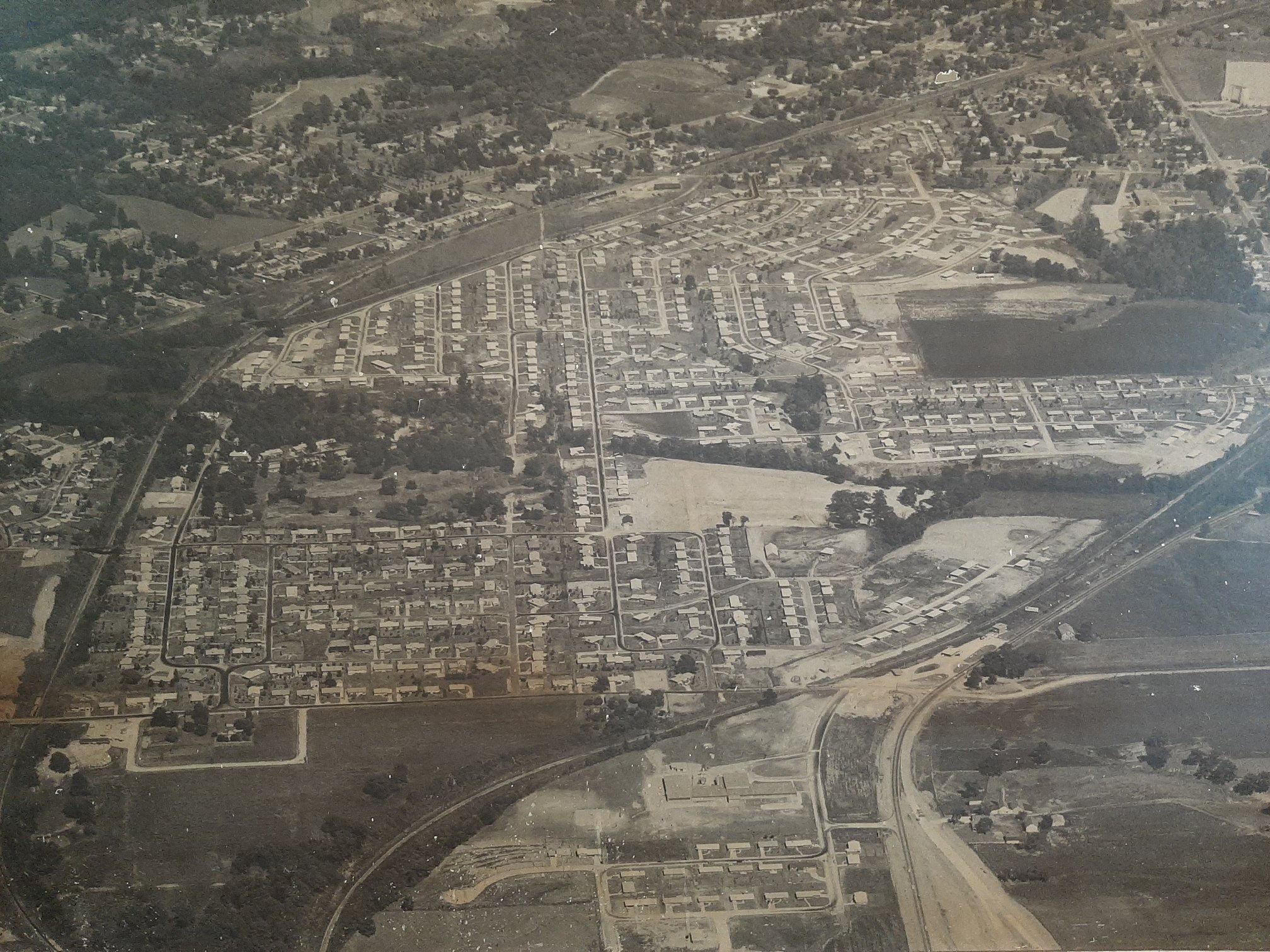
74th St is at the bottom as is the Emge Junior High School, was just recently built. The subdivision next to Emge is under construction,
St Matthews Church hadn’t been built yet, but the Country Club Heights and Shepherd Hills Subdivisions around it have been mostly built out. The big filed just above where the church should be in this photo became the 5th and 6th additions to Pinecrest.
You can see County Club Acres between Longview and Werner had not been built yet and most of the subdivision was still field.
Mitchell Place was mostly built out as were the Atlee Ogles 1st and 2nd additions. The 3rd, 4th and 5th additions were still being built out, with the 5th just being started. There appears to be a retention pond where the 6th thru 11th additions to Atlee Ogles are today.
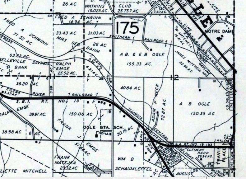
Shortly after the state of Illinois was formed, the grid system was used to create large plots of land (about 160 acres) that were then sold to private owners (farmers). Section 12 on this 1936 map of Stookey and Part of Belleville Townships divides the Ogles Neighborhood into 4 square plots.
If you compare the 1936 map to the above subdivision maps, you can see the vertical line in Section 12. Except for Country Club Acres, which is shifted 1 row of houses to the east. The horizontal line in Section 12 is the property line between the houses on the south side of Yorker/Winchester and the north side of Southgate. 74th St ran along the west boundary of Section 12. Note how 74th St continued over the RR tracks and North Belt. It continued all the way to what is now IL-158 near Millstadt using what is now Clover Leaf School Rd, Whispering Woods Dr, Boyd Rd and Eymann Rd.
The northwest quadrant became the Country Club Heights (thru 3rd addition), Country Club Acres, and Briarwood subdivisions. You can see a road running to a house south of the tracks. This became Werner Rd. According to the 1940 census, (ED 82-128, pg 23) 66 year old widower William Werner is listed as renting a farm near that location on S 74th St with his son’s family.
The northeast quadrant became the Melwood and Mitchell Place subdivisions. This quadrant was cut in half by the Southern RR and St Louis and Belleville Electric RR tracks. The old Belleville City limits was on the east side of the tracks. The entrance to the Avery Mine is at the end of 65th St. You can also see an entrance to another mine by the RR tracks at 59th St.
The southwest quadrant had been split in half. The Illinois Central RR tracks and North Belt slice thru the quadrant. It appears the house for the lot on the left was where Westfield Plaza is today. The left lot became the Country Club Heights (4th& 5th additions) and Shepherd Hills subdivisions. The Adam P Keck lot became the Pinecrest subdivision and the road to the house became Ladue Rd. According to the 1940 census, (ED 82-128, pg 22) 55 year old single Adam Keck is listed as owning a farm valued at $2500 at that location on RR 3 and lived with his single older sisters.
The southeast quadrant became the Atlee Ogle’s Subdivision, however, some of the plot had been parceled out before then. The road to the house in the north of the plot became the original entrance to the Atlee Ogle’s and Mitchell Place subdivisions. The house on the east of the plot is probably 2313 Frank Scott Pkwy W (built in 1937 according to Zillow). I was not able to find it or the farmhouse in the 1940 census.
You can also see which properties were annexed into Belleville. The Keck. Mitchell and the AB Ogles land were annexed into Belleville. The AB & EB Ogles land and the unnamed lot (all of County Club Heights and Shepherd Hills) are still in Stookey Township. Most of County Club Acres is also still in Stookey, except for the houses in the County Club Acres AP #1 subdivision on the east end. This strip of land was a part of the Mitchell lot in the northeast quadrant. For some reason, this part of the property was not developed as part of Mitchell Place but was still annexed into Belleville.
There is a little slice of Belleville that slices into Country Club Acres AP #2. This strip of land may be a conservation area. The undeveloped lots across the street are owned by “St Clair County Trustee”. In the 1936 map, you can see that a creek began in this area.
Links:
St Clair County Parcel Viewer. The parcel viewer is map with all the property boundaries overlaid. Click on a pacel and info on the property will pop up.
St Clair County Parcel & Real Estate Tax Inquiry page will give ownership information, sales dates and prices (since the 80s or 90s) and if you view the property record card, detailed information including building outlines and year built information can be found.
These 1936 maps were a great resource.